Left Haines Junction around 7:30 this morning and headed down the Alaska Hiway to Whitehorse. Road was good (by their standards, anyways), day was clear with no RAIN, and it was brisk but tolerable. The terrain on this leg of the Hiway is sort of a high plain as you can see from this shot taken about halfway between Haines Junction and Whitehorse:
The mountains in the distance are the Alsick Range. As you can see, though, the land is pretty scrubby and believe me...pretty uninhabited.
I got to Whitehorse around 10:00, grabbed some coffee, and then headed down the Klondike Hiway to Skagway, about 100 miles away. Pat and I had been to Skagway in 2003 when we took an Alaska cruise and thought it was interesting. Well...without any cruise ships in port, which there were none of today, there ain't much going on. Take a look:
It must have looked a little better from the ship. Anyway, there it is...save yourself a trip.
The scenery, though, from Whitehorse down to Skagway and particularly over Chilkoot Pass, was spectacular:
Skagway was one of the two main jumping-off points for the Yukon Gold Rush in 1898 and it's here that the famous picture was taken showing men nose-to-heel climbing Chilkoot Pass to get into the Yukon. The Canadians required that each man allowed to proceed had 2,000 lbs of supplies, enough to last a year, and they hauled those supplies over the pass 60 lbs at a time. To give you an idea of how desolate the terrain is, this is the top of the pass:
This extended for miles alongside the road. The temperature today must have been about 40 and the wind had to be blowing 40 miles/hour.
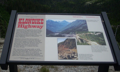
The Klondike Hiway itself was interesting. It was only opened in 1978 and before that, the only passage over the pass to Skagway was by foot or by rail. Take a look:
The top of the pass was about 3,500 feet, starting, of course, at sea level in Skagway. I would guess it was about 15 miles to the top.
After clearing the pass, the terrain gradually goes downhill to Whitehorse. This is a view taken from along the Klondike Hiway overlooking the Yukon River:
Anyway, very good day with good weather. Headed to Watson Lake, Yukon tomorrow, after which I'll turn south on the Cassiar Hiway (BC Hwy 37) which heads south thru the west-central portion of British Columbia. Miles today: 315. Total: 6,586.


