First off...Happy Birthday to our son, Patrick, who turned 26 today at 7:50 pm CDT!
Left Bend around 8:00 this morning and headed south on US 97 to Crater Lake National Park, about 100 miles south of Bend. Weather was beautiful and the skies were blue. I arrived at the Park around 9:30 and entered from the North Entrance off Hwy 138. This'll give you some idea of the terrain as you enter the Park from the north. This was just south of an area known as the "Pumice Desert" and it was desert-like:
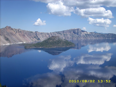
I took some pictures of the Lake at Merriam Point, a little further up the road from here, but since I was facing into the sun, they didn't turn out quite so well. I rode on up to Rim Village, the main tourist area in the Park and probably the best vantage point of all. It's hard to describe how blue the water is and how stark the contrast with the surrounding area the Lake is, but here are a couple shots to give you some idea:
The small island is "Wizard Island", which is actually a second volcano that formed after the eruption that created the caldera. The boat you see is a tour boat operated by the Park Service. By the way, Rim Village, where this picture was taken, is roughly 1,000 feet above the surface of the lake.
This should give you an idea of how blue the water is. It's unbelievable how majestic the Lake is and I'm afraid my photography doesn't lend it justice. Some interesting facts about Crater Lake: The eruption which created the lake took place about 7,700 years ago and it took about 800 years to fill the lake to its present depth. Maximum depth of the lake is 1,943 feet, its maximum width is 6 miles, and the elevation of the water is 6,173 feet. The Park averages 44 FEET of snowfall a year. (Pat and I were there in May, 1978 and there was a steel culvert at Rim Village that had to be 10 feet in diameter that was put in place the previous fall. Walking thru the culvert was the only way to see the lake and the culvert itself was completely covered with snow.) Anyway, along with Mt. St. Helen's, Crater Lake is one of those "gotta sees" if you're in this part of the country. It's magnificent.
I headed out of the park around noon via Hwy 62 toward Medford, Oregon and I-5. The scenery was beautiful leaving via the South Entrance also, and you can see how tall the trees were alongside the road on the way out.
This was probably 20 miles south of Rim Village on Hwy 62. Along the way out of the Park, I stopped at Rogue River Gorge, a nice little pull-off alongside Hwy 62:
From here it was on to Medford, Oregon and I-5 south to Redding, CA. Along the way, I passed by Mt. Shasta, which deserves its moment in the limelight:
This was near Weed, CA on I-5. Tomorrow, it down to Oakland and Patrick's apartment. Miles today: 330. Total: 9,019


